Land development & Topographical Surveying
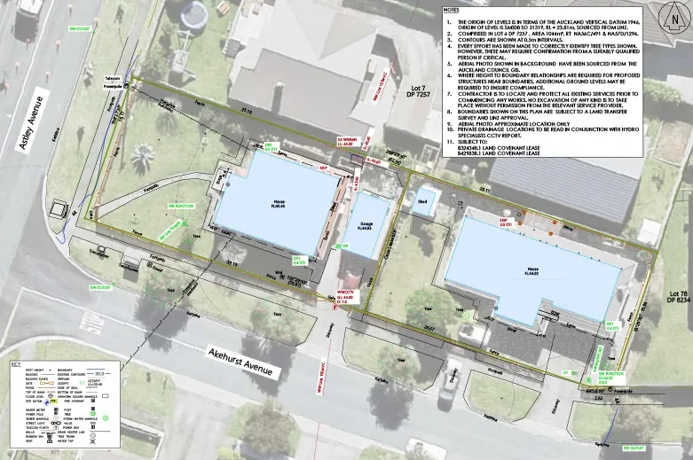
A topographical survey will give you detail on your land and its features. That makes it vital when planning a land development. It will measure and show you the slope and accurate ground levels on your development site.
Once your architect or consultant receive a topographical survey, and they will use the topographical survey information to design your new development or building and ensure all Council regulations are adhered to.
For this reason, almost any time a landowner decides to build a new building that requires Council approval, a topographical survey will need to be undertaken and completed before any architectural or engineering designs can be submitted.

What is included in a Topographical Survey?
As explained above, a topographical survey will include:
- Land contours
- Services
- Roading and concreted areas
- Significant trees
If you are planning to extend an existing building, the survey report will also include aspects such as the building’s:
- Location on site
- Floor levels
- Gutter levels
- The roof heights in relation to neighbouring boundaries
Topographical Survey FAQ
What does a survey cost?
The cost of a survey can vary depending on the type of survey, the size of your property and the age of the underlying and surrounding survey data related to your property. We can provide an estimate of survey costs at the start of a project.
When will I need a topographic survey?
Generally, land development and subdivisions projects require a topographical survey to position key features, such as buildings and drainage, and take levels over the site. The topographic survey information is then provided to other disciplines e.g. Architects, involved in the design of your development.
The Subdivision Process
The subdivision surveying for every land development we undertake follows the same five-step process to ensure complete transparency and satisfaction for every Thornley and Associates client.
Book A Free Desktop Assessment!
Get honest feedback about the feasibility of your project from highly experienced registered professional topographical surveyors.


